Digitální dvojčata staveb a památek
Přesná digitální replika objektu pro správu, analýzu, rekonstrukce i dlouhodobý monitoring.
Propojujeme LiDAR, fotogrammetrii, termovizi a další datové vrstvy do jednoho inteligentního modelu, který umožňuje objekt vidět, analyzovat a spravovat v digitálním prostředí.
Jednotný model · více senzorů · práce v čase
Základ
Co je digitální dvojče
Věrná digitální replika reálného objektu — nejen vizualizace, ale strukturovaný model pro rozhodování.
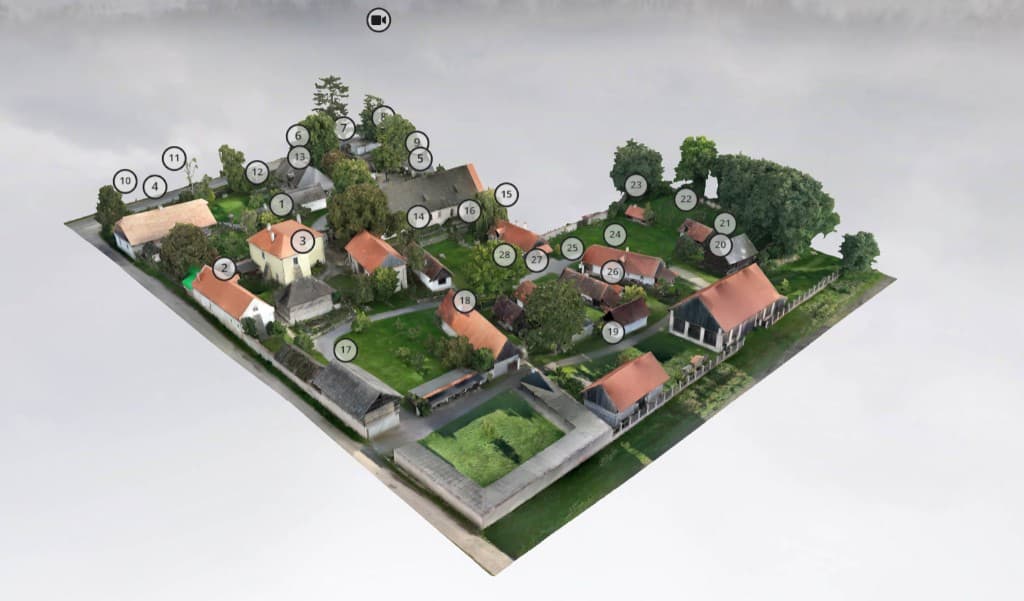
Digitální dvojče je věrná digitální replika reálného objektu, která propojuje přesný 3D model, prostorová data a další navázané informace do jednoho celku. U staveb a památek umožňuje detailně zachytit geometrii, stav konstrukcí, povrchové změny i vybrané provozní nebo environmentální souvislosti. Výsledkem je inteligentní datový model, se kterým lze pracovat online, porovnávat jej v čase a využívat jej pro správu, dokumentaci, obnovu i prezentaci objektu.
Rozsah
Co služba zahrnuje
Od terénního sběru přes zpracování až po sdílení a dlouhodobé sledování — v jednom logickém celku.
Sběr dat
- letecká fotogrammetrie
- LiDAR skenování
- termovizní snímání
- multispektrální doplňková data
- pozemní doplňkové doměření
- georeference pomocí RTK a vlícovacích bodů
Zpracování dat
- tvorba point cloudu
- tvorba mesh modelu
- ortofotomapy a přesné podklady
- klasifikace a čištění dat
- optimalizace modelu pro web, prezentaci i projekci
- možnost přípravy BIM-ready podkladů
Digitální prostředí
- online prohlížení modelu
- klientská zóna / cloud
- sdílení v týmu
- VR / AR vizualizace
- možnost navázání dalších datových vrstev
- dlouhodobý monitoring a porovnání změn
Aplikace
Kde digitální dvojče dává smysl
Od památek po infrastrukturu — stejná metodika kvality dat, jiný kontext interpretace.
Historické objekty a památky
Zámky, hrady, kláštery
Městské budovy a veřejné objekty
Průmyslové areály
Developerské a stavební projekty
Technická infrastruktura
Krizové a havarijní situace
Objekty určené k rekonstrukci nebo dokumentaci
Hodnota
Přínosy pro klienta
Nejde jen o vizualizaci — jde o provozní a strategický přínos pro správce, vlastníky i projekční týmy.
Jednotný zdroj přesných dat
Jeden referenční model místo roztříštěných souborů a verzí z různých zdrojů.
Monitoring změn v čase
Opakovatelné měření a srovnání stavu — podklad pro údržbu, investice i pojistné scénáře.
Podklad pro rekonstrukce a obnovu
Geometrie a dokumentace v úrovni detailu odpovídající zadání a regulatorickým požadavkům.
Vyšší bezpečnost a prevence rizik
Lepší přehled o stavu objektu a okolí — méně nejistoty při rozhodování.
Moderní prezentace objektu
Od odborných výstupů po srozumitelné prezentace pro veřejnost a partnery.
Lepší rozhodování
Data ve struktuře, která podporuje analýzy, priority a plánování rozpočtu.
Deliverables
Výstupy pro klienta
Formáty a úroveň detailu sladíme s cílovým použitím — od správy majetku po projekční práce.
- 3D model objektu
- bodové mračno
- mesh model
- ortofotomapa
- výškopisné a polohopisné podklady
- online viewer
- cloudové sdílení
- termální a analytické vrstvy
- srovnání v čase
- exporty dle požadavků klienta
Web & cloud
Viewer, role, archivace a sdílení v týmu.
Mapy & orto
Georeferencované podklady pro GIS a projekci.
Analytické vrstvy
Termo a další vrstvy dle zadání.
Exporty
Strukturované předání podle workflow klienta.
Ekosystém
Propojení technologií
Jeden inteligentní model stojí na více vrstvách pravdy — od povrchu po podzemí a provozní signály.
Nad zemí LiDAR, pod zemí GPR — kompletní obraz reality.
LiDAR
přesná geometrie a struktura objektu
Fotogrammetrie
vizuální realita a textury pro prezentaci i měření
Termovize
tepelné souvislosti a anomálie obálky
GPR
podzemní struktury a kontext pod povrchem
Multispektrální data
vegetace a doplňkové analýzy okolí
Autonomní monitoring
dock řešení a opakované mise pro trendy v čase
Důvěra
Proč HORDRONES
Technologie jsou nástroj — výsledkem musí být data, která obstojí u správců, projektantů i veřejné kontroly.
Kombinace více senzorových technologií v jednom projektovém rámci.
Zkušenost s technickými i historickými objekty — od detailu po areály.
Přesná georeference a kvalitní datové zpracování s kontrolními body.
Vlastní přístup k online vizualizaci a sdílení v klientské zóně.
Možnost škálování od jednotlivých objektů po rozsáhlé lokality.
Výstupy přizpůsobené reálným potřebám klienta a interním procesům.
Spolupráce
Balíčky služeb
Orientační struktura — finální rozsah vždy podle objektu, přístupnosti a cílové přesnosti výstupů.
Basic
Rychlý vstup do 3D reality objektu
- ✓základní 3D model exteriéru
- ✓fotogrammetrické zpracování
- ✓online náhled
Pro
Nejčastější volba pro projekty a správu majetku
- ✓kombinace fotogrammetrie a LiDARu
- ✓detailnější model
- ✓ortofoto a přesnější datové podklady
- ✓cloudové sdílení
Enterprise
Komplexní digitální dvojče pro náročné scénáře
- ✓komplexní digitální dvojče
- ✓více datových vrstev
- ✓možnost interiéru i exteriéru
- ✓časové srovnání
- ✓napojení na BIM / interní workflow
Digitální dvojče
Chcete převést svůj objekt do přesného digitálního prostředí?
Navrhneme vám řešení na míru podle typu objektu, požadované přesnosti i způsobu využití výstupů.
LET'S WORK TOGETHER
Send an inquiry — we will reply with a timeline and recommended approach.
Poptávka